Taken from the STRICTNet school website (2000-2010)
The Founder's Trail is a journey around Gloucester visiting all the places and points of interest relating to our school's history, development and its founder Sir Thomas Rich. Put together by Mr A S Pilbeam, this trail is followed each Founder's Week by all Year 7 pupils so that they may appreciate some of the history and traditions of the school - and thereby the greater community of Richians - to which they now belong.
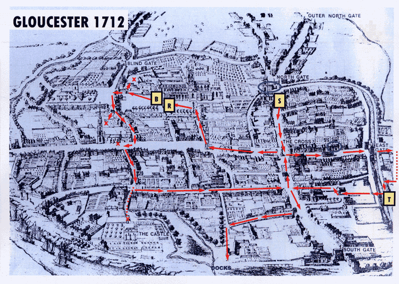
The trail starts at "S" and follows the red arrows on the above map, which is a copy from an engraving of a map of the City of Gloucester in 1712. At each point snippets of information are given and observational questions posed. All information, directions, etc correct at time of compilation (May 2003)
Thomas Rich was baptised here in August 1601. It was the family church and there is a significant memorial here.
What is it?
One of the annual school carol services is held here.
This street became the home of many professional people. There exist today good examples of late 19th century buildings and the Guildhall is on the site of the original school. The first school used the family house of Sir Thomas Rich but then it was known as The Blue Coat Hospital. The building is marked on the engraving near the Barley Market which is in the middle of the street. Houses nearer the Cross were more prestigious.
How many premises are there between the Cross and the School?
What is correct but surprising about the information on the plaque?
Two famous poets were born in or just off Eastgate. Who were they?
One wrote: 'Who says Gloucester sees a tall fair fashioned shape of stone arise, that changes with the changing skies from joy to gloom funereal, then back again to joy; and sees those four most ancient ways come in to mix their folk and dust and din with the keen scent of the sea-breeze?'
To what three features of the city is he referring?
Which two buildings remain from the time when the school was here?
What was the date of the siege of Gloucester?
Who or what was 'Humpty Dumpty'?
Who ordered the demolition of the city walls and when?
Beyond the East Gate the street is called Barton street. What is it called now?
At the entrance of School House is a shop that sold buns at break time to the boys.
What is the name of the shop?
What was the earlier name of School House?
Between what dates was the School here?
Barton Street was once a fashionable residential street. Several large houses remain from this period, including School House.
Best seen from the south side, what is their chief architectural feature?
All the classrooms, laboratories, hall and library have been demolished. The School occupied the whole carpark site.
What is the name of the notorious street leading from the south side of the old playground?
Jennings were the printers of the Richian magazine. School lunches were provided in Friars Orchard where the concrete building at the rear of Gloscat stands today.
To what monastic order did the Greyfriars belong?
What was the date of the first Sunday School?
For what purposes was it founded?
Another old Gloucester school is the Crypt School. This was next to the St Mary de Crypt Church.
Between what dates was the Crypt School sited here?
When did it move to Tuffley?
When did Sir Thomas Rich's move to Elmbridge?
Robert Raikes was one of the founders of the Sunday School movement. What symbols appear on the sign hanging on the front of his house?
Just off of Westgate Street by The Citizen newspaper offices in St John's Lane there can be found some information plaques with further information about the Raikes family and its involvement with The Citizen and how Robert Raikes got to found the Sunday School movement.
Notice the side of 26 Westgate. Most old houses in Gloucester were half-timbered. Westgate Street was the main market street of Gloucester. Many Old Richians were apprenticed to tailors.
Who wrote 'The Tailor of Gloucester'?
The School has often held services in the Cathdral. There were special seats reserved for Blue Coat boys for Sunday services. Memorials to men connected to two other well known Gloucestershire schools are on the wall of the south trancept.
Who are these men?
What are the names of the items presented by Sir Thomas Rich to St John's Church which are now displayed in the Cathedral Treasury?
What king is buried in Gloucester Cathedral?
What king was crowned in the Cathedral?
To what monastic order did the abbey belong?
In Millers Green the Parliament Room may be seen. The half timbered upper part is 15th century but the lower part is 13th century. Richard III held court here. It was here that William the Conqueror ordered a famous survey.
What was the name of the book recording this survey?
To the south-west of Bishop Hooper's memorial against a modern wall is a statue of which king?
When was the statue first erected?
What is the significance of that date to Gloucester?
What is the connection between this king and Sir Thomas Rich?
What family once owned St Nicholas House, 100 Westgate Street?
What formerly stood where the prison is today and what reasons can you suggest for its being there?
Which house is still standing in Longsmith Street and is shown on the engraving?
It is possibly the finest town house in Gloucester.
The original port of Gloucester was along the Quay.
When was Gloucester granted port status?
This meant it could handle goods from other countries. The dock basins were dug in the early 19th century.
What were the main cargoes the port handled?
To find out more about Gloucester Cathedral, The Docks and the City of Gloucester itself, click on the links below .....
Gloucester Cathedral
Gloucester Docks
City of Gloucester